We use cookies to improve your experience on our site. To find out more, read our privacy policy and cookie policy

Nextspace platform

An open, scalable ontology platform for AI-ready digital twins
Contact Us

Beyond digital twins

Nextspace is an ontology-driven platform that unifies engineering, spatial, and operational data into one AI-ready fabric.

Instead of replicating or locking data into a single system, Nextspace connects 2D, 3D, GIS, IoT, documents, and enterprise data into a unified ontology that preserves context and relationships.

Through this model, you can:
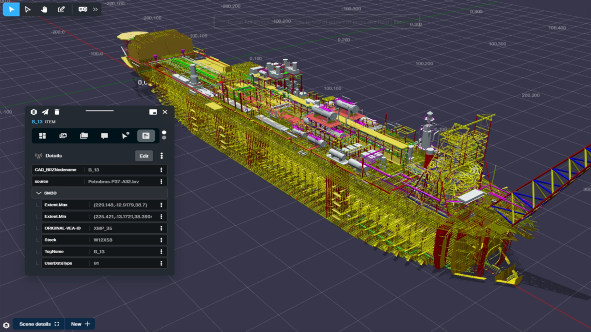
Visualize assets in 2D, 3D, or geospatial views – right down to nut-and-bolt level, enriched with attributes, documents, relationships, and live system links.
Analyze complex systems in the browser without performance compromise.
Orchestrate AI to interpret, predict, and optimize operations across all connected data.

This ontology-first approach transforms digital twins from static visual replicas into dynamic, intelligent, and scalable systems of record for critical infrastructure

From disconnected silos to AI-ready fabric

No single dataset solves complex challenges. Nextspace federates all your data into a single model, enabling AI to reason, predict, and optimize across systems

Engineering and asset data

BIM, CAD, GIS, and EAM data modeled together

Dynamic operational data

IoT, work orders, and enterprise systems unified without duplication

Rich context at scale

Point clouds, LiDAR, and multimedia linked directly into the ontology

Beyond pictures, into intelligence

Nextspace’s knowledge graph unlocks the value hidden in siloed data.

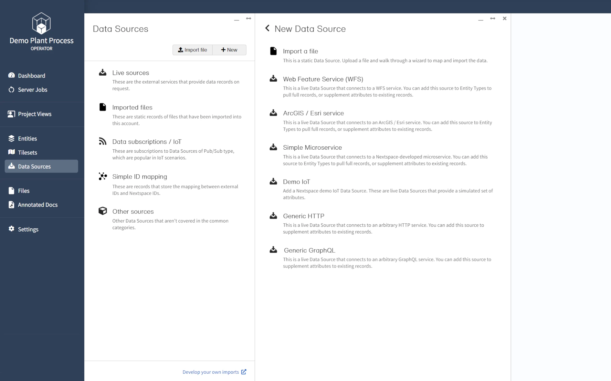
Start with incomplete sources, add more as you go, and let the ontology evolve without costly “data cleansing” projects.

Your data isn’t ready for AI. Nextspace makes it ready.

Most AI initiatives stall because critical data sources can’t talk to each other.

Engineering, spatial, and operational systems all run on incompatible taxonomies and schemas – leaving organizations with silos, blind spots, and unreliable insights.

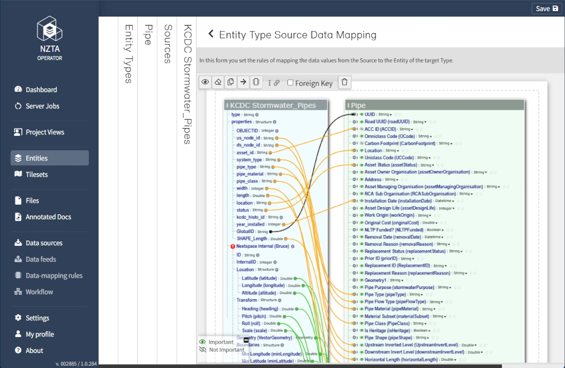
At Nextspace, we solve this by unifying engineering, GIS, BIM, IoT, financial, and work order data into a single, queryable ontology.

From there, we make it human-friendly (2D, maps, 3D,4D visualizations) and AI-ready (APIs, MCP, and digital twin streaming to analytics & simulation systems).

The result: trustworthy data, faster AI deployments, and measurable improvements in performance, safety, and profitability.

Nextspace ontology

/ɒnˈtɒlədʒi/
noun
1. Describes the relationships that exist between each and every thing and/or component in your digital twin.

Ontology and why it matters

Ontology is a strategy for organizing structured and unstructured information using entities, properties, and relationships.

Nextspace lets you create your own ontology that joins all of your data and data schemas into a single, virtual shared source of truth for decision-making and capturing decisions within a large organization.

By providing a single source of truth, ontology enables users to easily discover and understand data across their organization as well as view their local decisions in a more global context.

Operator

Data schema mapping is as simple as drawing a line between two points. Or let AI do it for you.

Operator

Import virtually any file type via drag and drop, or connect via API

Operator

Easily unify seemingly incompatible data types using our nodal-based conversion tools

Navigator

Link back and forth between a 3D object and its twin in 2D drawings

Operator

Rearrange and connect complex data sets with intuitive click and drag

Operator

Geolocate your 3D assets using EPSG data and then make final adjustments manually

Digital twin framework with Nextspace

Descriptive
Visual
2D / 3D
Geospatial
Spatiotemporal / Animated
Informative
Data Driven
(static, dynamic, live)
Attribute
Visualization
Query
Interactive
Fully interactive
2D / 3D (i3D/XR)
Explorable
Discoverable
Intelligent
Rules-based visualization
Data-driven context rules
Contextualized
Integrated Data Analytics and AI/ML
Predictive
Physics-based modeling
Real-time scenario planning
Recommendations
Real-time predictive analysis and action
The Ontology-First Digital Twin Platform
Make your data ready for humans and AI
Most organisations struggle to unify engineering, GIS, BIM, IoT, and enterprise data. Nextspace solves this with an ontology-first platform that turns disconnected information into a living, queryable, and visual model of your operations — ready for analytics, simulation, and AI.

At a glance:

Unify every data source into a single ontology — not just a federated file view.
→ Visualise assets, systems, and processes across 2D, GIS, 3D, 4D, and documents.
→ Activate AI, LLMs, and simulations through open APIs and the Model Context Protocol (MCP).
Built from 30+ years of aerospace and defence experience in data modelling, Nextspace delivers the performance, security, and scalability required for critical infrastructure and industrial environments.

MacBook mockup
Unified Data & Ontology
One model, many sources.
Nextspace unifies engineering, geospatial, IoT, document, and enterprise data into a single, dynamic ontology that describes how everything relates and behaves.
AI-assisted schema mapping — Match and merge data models (BIM, GIS, SCADA, SAP, Maximo, etc.) in minutes.
Entity-based architecture — Every pump, valve, or runway light becomes an entity with unique attributes, geometry, and lifecycle state.
Temporal versioning — Changes are time-stamped, allowing playback and prediction across past, present, and future.
Ontology governance tools — Define, validate, and evolve your schema as your operations grow.
Result: A single source of truth that connects meaning — not just files.
Visualization & Interaction
Visual proxies for every audience.
Nextspace treats visuals as attributes of data — not static renderings. This allows humans to interact with the same ontology through different lenses.
2D, map, 3D, and 4D views — Switch seamlessly between schematic, spatial, and geometric contexts.
Cross-referencing — Click any entity to jump between its representation in drawings, maps, and documents.
Gaussian splat rendering — High-fidelity point-cloud and photogrammetry integration for realistic spatial context.
Markup & collaboration tools — Annotate, comment, and share directly within the model.
Result: From engineers to executives, everyone sees the same truth — in the view that makes sense to them.
MacBook mockup
MacBook mockup
Open Integration & Extensibility
Connect anything.
Extend everything. Nextspace was designed for interoperability — not lock-in.
Connectors & import tools — BIM/CAD (Revit, Navisworks, IFC), GIS (Esri, MapInfo), IoT (OPC-UA, MQTT), EAM (SAP, Maximo), databases, and more.
REST & GraphQL APIs — Secure, documented, and ready for automation or partner extensions.
Plugin framework — Build your own analysis or visualization extensions.
Enterprise authentication & access control — Integrate with Azure AD, SAML, and other identity providers.
Result: Your data stays yours — portable, extensible, and always accessible.
AI, Analytics & Simulation
From visualization to intelligence.
Once data lives in the ontology, Nextspace makes it available for reasoning, prediction, and simulation.
Low-code rule engine — Trigger alerts, workflows, and business logic.
Predictive analytics — Integrate sensor data and machine learning for anomaly detection and maintenance forecasting.
Natural language queries(beta) — Ask questions in plain English and get visual answers powered by LLMs.
Simulation pipelines — Model “what-if” scenarios: capacity, failure, climate risk, and more.
Embedding & RAG support — Feed ontology data into AI agents for context-aware responses.
Result: Turn operational data into foresight, not hindsight.
MacBook mockup
MacBook mockup
Scalability, Security & Governance
Enterprise-grade, cloud-ready, and on-premise capable.
Deploy anywhere — cloud, private cloud, or on-prem (air-gapped deployments supported).
Multi-tenant architecture — Separate environments for projects or clients, with fine-grained access.
Audit & version control — Every change recorded, every ontology version traceable.
Performance optimized — Proven scalability to millions of entities and terabytes of 3D and IoT data.
Compliance ready — Designed for ISO/IEC 27001 and government security frameworks.
Result: Built for the data sovereignty, scale, and security that critical infrastructure demands.
Ready for What’s Next?
Nextspace continues to evolve — integrating LLM interfaces, Gaussian splat visualization, and real-time IoT graph updates into a single, AI-ready platform for infrastructure, manufacturing, and beyond.
Your data isn’t ready for AI. Nextspace makes it ready.
Request a demo or contact us to explore how ontology can transform your operations.
Nextspace is a Platform as a Service software solution for the integration of BIM, CAD, point clouds, photogrammetry, GIS and IoT data with associated asset, work and operational business information and documents to create living, breathing data-rich digital twins.

To use the Nextspace platform, you’ll need a PC, Mac or tablet running a Chromium or WebKit browser with WebGL support, such as Chrome, Edge, Firefox or Safari. Overall performance is typically dictated by internet speed (15 Megabits per second or faster) and 3D graphics performance of the client device. A graphics card with a G3D mark of 1,000 or higher is recommended.

General

Import CAD, BIM, Point Clouds, Photogrammetry, 3D Reality Meshes, GIS and 2D data.
Direct connect to enterprise systems such as Esri, SAP, Maximo.
Direct connect to live data such as IOT and SCADA.
CesiumJS, Unreal Engine and Omniverse based 3D geospatial viewers.
User permissions and access control management
Manual and AI-powered data schema mapping
Spatial and data search
Associate documents to Entities (attachments or links)
Plugins: add new functionality to the Nextspace platform.
Webhook: allow your app/services to submit a web-based notification to the Nextspace platform.
Stream data from the likes of Google 3D (Photorealistic Tiles), OSM 3D Buildings and CyberCity 3D (buildings).
Stream WFS and WMS data feeds
Import your own basemaps (topo/aerial) and terrain or use ours.
API: access, configure and customize the Nextspace platform.

Platform Components

Operator (module)

Nextspace API
Access the Nextspace digital twin platform and/or customize and/or configure the Operator and Navigator modules to meet your organizations particular needs. Documentation and support additionally provided.
Data Sources
Import 2D and 3D files to create Entities or visual proxies (for Entities). Import basemap and terrain data. Create or use existing Nextspace supplied API connections to enterprise systems to pull/push data in real-time or periodically. Create API connections to live data sources (or data hubs), such as IoT and SCADA. Additional functionality includes the tools and features mentioned in Data Schema Mapping. Create, update and re-use import standards for BIM and CAD data
Data Schema Mapping
A set of tools - manual, automated and AI-powered - for the mapping of data schemas from multiple incoming data sources (ETL, API or real-time) to one or more agreed data standards. Define how data should be converted between the schemas of external data sources and new or existing target data schemas. Additional tools include coordinate system conversion, geocoding (finds lat/long for a given property address), and unit conversion.
Entity Types
A comprehensive suite of tools for creating and managing Entity Types (person, organization, object type or concept about which information is stored),
Entity Styles (2D, 3D & Parametric)
Styles can be applied across multiple Project Views and act in a hierarchical manner. Styling options include - across multiple geometry types - color, line width, pixel size, etc. Styling can also be controlled using attribute values directly, by mapping certain attribute values to specific style options in a list or by user set ting max/min values. Multiple altitude options can also be set in Entity Styles
Data Lab
A powerful tool for searching and bulk updating of Entities.
Data Relationships
Create, edit and delete data relationship types (and their schemas). Example relationship types include upstream of, downstream from, inside of). Can also add, edit and delete graphically how data relationships are visualized.
Tags
Tags are a convenient way to group Entities together for managing access and filtering content for user groups and managing visibility to users. Tags may be general or specific to an Entity Type.
Explorer
A graphical interface for finding, listing, filtering, editing, deleting and exporting Entities.
LOD Management
Customize the visual proxies for Entities. Ability to specify a different model representation for each level of detail.
Cesium Tilesets
Add, edit, export and delete Cesium Tilesets. This includes creating Cesium Tiles from scratch (bring your own); processing and creating from Entities (2D, 3D & GIS geometry) based on Entity Styles; and linking Cesium Tilesets from another Nextspace account.
User Management & Access Control
Add Users and create User groups and set their functionality and access control permissions.
Project Views
Publish your project/data to a Project View (PV), which is then accessed by an end user using the CesiumJS, Unreal Engine or Omniverse Nextspace viewers. Add, edit and delete PVs; brand PVs; PV user management access control and permission settings; InfoView panel appearance and feature editing (per PV); custom form creation and editing (per PV);
Custom Forms
Enhance Entity details with rich custom layouts/forms and embedded HTML\iFrame content. This also includes displaying dashboard type charts and graphs that represent attribute values, such as live IoT sensor readings.
Hotspotting
Creation of intelligent bidirectional linking between 3D model data and associated objects represented in 2D drawings (P&ID, GA, Isometric, etc).
Attachment Management
Files attached (or linked externally) to Entities. Manage these attachments (files), their type and their grouping.
Account Backup
Manually or set automatically the backup of the data in your Nextspace account.
File Management
Management of all files that have been imported or processed within your Nextspace account.
Plugins
Support for external software that can add new features or extend existing functionality to the Nextspace digital twin platform.
Webhooks

Augment or alter the behavior of the Nextspace platform with custom callbacks.
Time Series Data
Import and associate historic data with entities. Visualize historic data using the Timeline in Navigator.

Navigator (module)

Dashboard
A dashboard dedicated to managing Project Views, viewing account data (Entities, storage) and managing users/user groups/permissions.
Project Views
Publish your project/data to a Project View, which is then accessed by an end user using the CesiumJS, Unreal Engine or Omniverse Nextspace viewers.
Basemaps & Terrain
Import your own basemaps (topo and aerial) and terrain or select ones already supplied (Cesium, Bing, MapBox, OSM, etc).
Scene Configuration
Change scene settings including ground occlusion, globe visibility, terrain wireframe, shadows, ambient occlusion, and Entity color.
Bookmarks
Save a configured scene (camera position, basemap, terrain, Entities Menu, markup, etc). Use bookmarks to tell stories with data.
Import (files)
Import 2D and 3D files to create entities or visual proxies.
InfoView Panel
A properties panel which displays information about Entities. Perform a variety of actions including: add, edit or delete attributes and values; delete Entities,; vew and add graphical relationships; attach images, files and links; fly to selected Entities; add comments; and more.
Entities Menu
Add, organize, edit or delete menu items. Menu items control the visibility of Entites, Cesium Tilesets and streamed data (Google 3D, OSM buildings, Cesium ION). The visibility settings are also saved to bookmarks.
User Tools
Select/Multi Select; Pan; Edit (position); Markup; Measure, Fly/Walk-Through; Comments; TImeline (date/time); Compass; and Presentation Mode.
Create
Create Entities directly on the map in your Project View by either selecting items from our 3D model library, drawing 3D shapes using our tools, or importing your own 3D models.
Search
Search Entities by attribute value using multiple criterion/filters and fly to resultant Entity/Entities.
Scene Tree (hierarchy)
View a hierarchical list of entities in the project view. From the list, filter using criterion and select entities. The resultant entities will also be selected in the scene.
Export (files)
Export a Bookmark to a screen capture image file, to another viewer (Unreal Engine and Omniverse) or selected 2D/3D geometry to a file.
Plugins
Support for external software that can add new features, or extend existing functionality, of the Nextspace platform.

Data sources

Nextspace Operator & Navigator

Import/registration of 2D and 3D objects (Entities):
BRZ
IFC (2x3, 2x4, 4x2 etc.)
DWG
DXF
Revit (2023) (2024 coming soon)
GeoJSON (both format and file extension)
KML, KMZ
NWD (beta)
CSV (comma, pipe and semi-colon)
LAS, LAZ
E57 (coming soon)
Cesium Tileset
TIF, TIFF
ZIP (7-Zip)
OBJ / MTL (coming soon
JT (beta)
ISO 15926 (XMpLant)
AVEVA (XMpLant)
Hexagon Intergraph (XMpLant)
Autodesk (XMpLant)
Bentley (XMpLant)

Nextspace Navigator

Import visual proxies for objects (Entities):
GLB
gLTF
FBX
DAE (coming soon)
SKP (coming soon)
GeoJSON (coming soon)
CSV (coming soon)
Cesium Tileset (coming soon)
OBJ / MTL (coming soon)
E57 (coming soon)
JT (beta)

Third-Party Apps & Data

Use third-party apps, such as pCon Planner, QGIS, FME, ThreeJS and SAP Visual Enterprise, to import data. For more information click here.
SHP, SHX
STEP
IGES
STL
OBJ
Other CAD and GIS formats not listed on this page
Using Nextspace API, pull and/or push data to external enterprise systems and live sources, including:
ArcGIS (ESRI)
SAP
IBM Maximo
SharePoint
IOT, SCADA, HMI, and other sensor data
Export data from the Nextspace platform in various formats, including:
KML & KMZ (with data)
DAE (without data)
OBJ (without data)
FBX (without data)