Complex multi-year infrastructure projects involve thousands of individuals with specialist expertise all working on the same project, all with different perspectives and roles.
Take the example of a highway extension—government planning, financing, legal, geotechnical analysis, earthworks, engineering, bridge construction and services involving paper and computer-aided designs, photos, videos, spreadsheets, manuals, specialist readings and different project management systems.
A data-rich highway is an opportunity to improve project and financial management and communication—not just during the build, but for the lifetime of the highway. Intergenerational challenges are where data makes a significant difference. This is all possible today, combining all the data sources into a single coherent view that evolves from concept, to tender, to construction and onto maintenance and retirement of the assets.
Nextspace's digital twin platform can acquire a wide range of base data including author mosaic photogrammetry data from drones to create a detailed 3D terrain model of the area flown. The platform can also import and unify CAD, GIS and BIM information into the model records of property and work consents, legal compliance. In-field decisions, work and sign-offs are also imported into the same single data model all precisely geo-located in the resulting digital twin.
Nextspace digital twins are cloud-based, so no software needs to be installed or managed. This also means new data is simultaneously available to everyone working on the motorway and remotely free or managed user access is controlled using military-grade security standards. Sharing updated views of the project is as easy as sending a bookmark to approved viewers. Within minutes of importing data, what looks like a custom computer animation created by animators is built from just the data alone. As data it is precise and readable by machines for use in analysis and simulation. As a visualization it is easily understood by people.
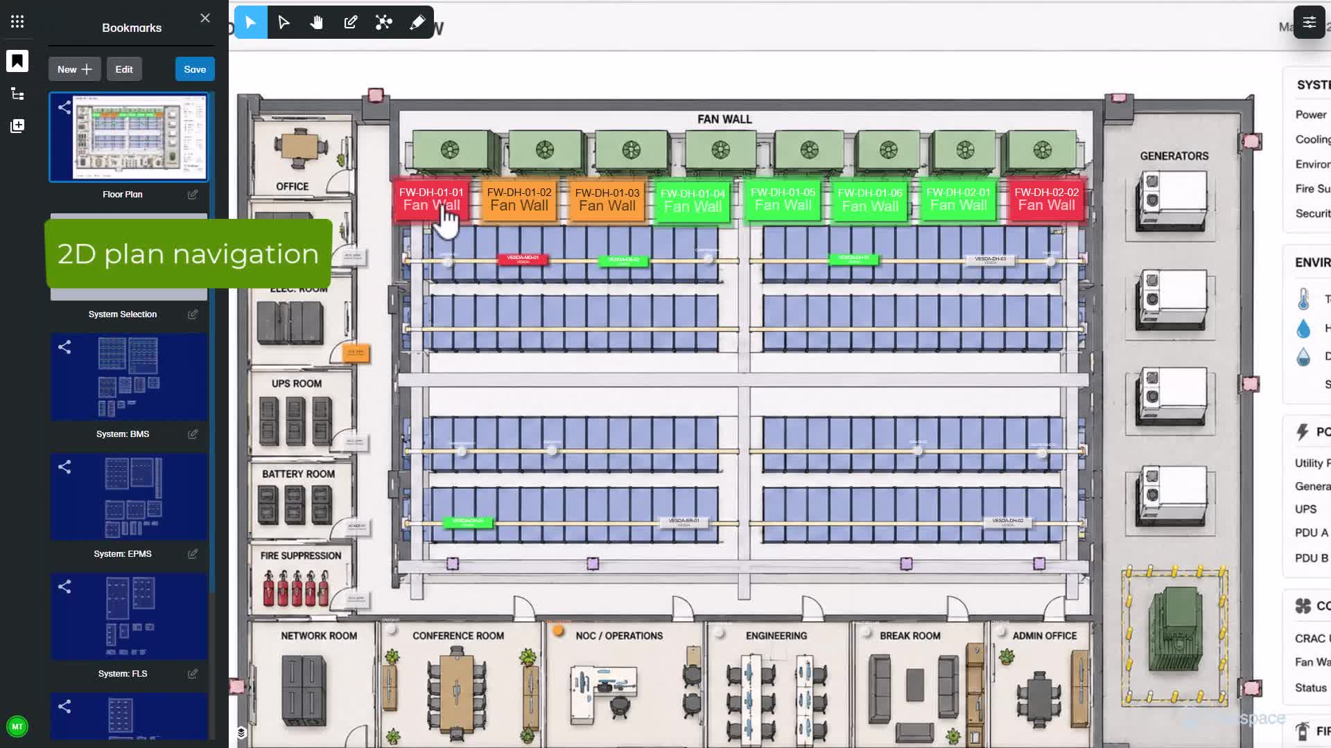
Being data generated, each visual element is capable of holding multiple layers of information, detailed records on the composition of any surface and what's buried under the surface, utilities and soil structure. The platform can also import IoT sensor readings such as bridge strain gauge monitors, live weather and sun direction, and tracking at any location. Information like the capacity for this stormwater wetland can be easily visualized. Attribute displays like the log entries for this one specific orga hole can be attached to its exact position because this information is different to that for the orga hole 50 meters away.
The digital twin can be used to instruct those in the field placing work orders. Instructions, symbols and icons in the model—these are easily changed, added and accurately positioned as the digital twin is created from detailed photogrammetry. Data point, length, angle and area tools are available. Gradients, sections, contours and slope analysis can be measured and visualized in multiple ways. GIS data such as land parcels, locations and utilities data can be added and overlaid on the 3D model. Records of consents and parcel ownership can be visually accessed once a build is complete.
Decades of maintenance begins—information collected during the build can be accessed in the field by teams that never worked on that build. Every asset is given a globally unique identifier. This connects scheduled maintenance of a specific stem adapter with a specific valve at a precise location and depth accessible for the full life cycle of the project. IoT sensor or SCADA readings can dynamically update. The digital twin detailed repair videos can be available to maintenance crews on call, on-site 24/7.
Other Nextspace technologies feed data into digital twins. A relevant one to our highway project is our entity detection. Artificial intelligence recognizing, locating and creating a database of motorway signage from video taken on a typical motorway journey, the same AI recognizes and locates potholes and can report when grass verges require maintenance.
One digital twin enables better conversations between on-site and remote specialists helping them work together as one team saving money, reducing work, site risk and unlocking previously unrealized value. When connected with each other, multiple digital twins combine to offer collective insights from multiple sites. Data unified and visualized ready for analysis and predictive simulations—this is not the hype of a future industrial metaverse, but a reality today with federated digital twins built with Nextspace.